
International Boundary Marker – Republic of Texas and the United States
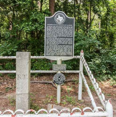
For more than a century, the area north of the Sabine River was disputed territory between France and Spain, then Spain and the United States, then Mexico and the U.S. After the Republic of Texas began in 1836, the Texas and U.S. governments established a joint commission to formally survey and mark the boundary between the nations. In May 1840, the survey crew began at the Gulf of Mexico, placing a 36-foot high pole in the middle of a large mound. They then placed eight-foot posts every mile along the Sabine River and then north to the Red River, finishing their work in just over a year because of various delays. The surveyors placed a four-foot high granite marker at the 32nd parallel along the international boundary just north of the Sabine River. The west side of the marker marked "R. T." for Republic of Texas, the east side is marked "U.S." and the south side is inscribed "Meridn Boundary, Established A.D. 1840". The shaft was prepared in 1840 but was not erected until the spring of 1841.
After Texas joined the U.S., the boundary between the nations became the boundary between Texas and Louisiana. A three-acre park developed and dedicated in 1976 memorializes the marker for a boundary negotiated by the U. S. with three foreign nations (Spain 1818, Mexico 1821, and Texas 1838). The site was designated a Historic Civil Engineering Landmark in 1976, listed in the National Register of Historic Places in 1977, and designated a State Antiquities Landmark in 2003. The following year, an Official Texas Historical Marker was added to the site southeast of Carthage off Texas State Highway 31/Louisiana State Highway 765, which straddles two states and several centuries.